Profiler / ADCP / CM Moorings Overview
Overview | Results
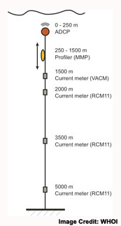
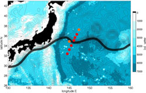 Seven deep moorings were deployed along a line in the CPIES array, across the axis of the Kuroshio Extension and extending south into the southern recirculation gyre. The moorings consisted of 3 deep Aanderaa RCM-11 acoustic current meters at 2000 m, 3500 m, and 5000 m. Above the RCM-11s a moored profiler traveled from 1500 m up to 250 m and back again every 15 hours. Finally, at the top of each mooring was an upward-looking acoustic Doppler current profiler (ADCP) which covered the near-surface velocity field.
The data will be collocated with CPIESs against direct measurements from the MMPs. With simultaneous measurements of temperature and salinity we will also be able to estimate the cross-frontal flux of heat and salt and, with the 2-year time series and CPIES map of the velocity field, expect to observe a number of occasions when North Pacific Intermediate Water (NPIW) is exchanged across the Kuroshio front.
 The instrument package within the McLane moored profiler (MMP) contained both a CTD and a 3-axis acoustic current meter, and through use of a traction drive system, climbed up and down a mooring line. Its power and recording capacity gave it capability to cover a total distance of 1 million meters (e.g., one up and down trip per day over 1.3 km for 365 days). The great advantage over conventional mooring systems, even those containing Doppler profiling instruments, is that profiles of velocity, temperature and conductivity are obtained.